
Dusty Trails and Hidden Waterways
Bikerafting the wetlands of Mabamba Bay
Written by Jan Bakker, photography Lawrence Musoke
Connecting peninsulas and islands by packraft and mountain bike, Packraft Africa founder Jan Bakker embarked on a mini-expedition through the less-seen side of Uganda. Jan’s journey took him beyond the tourist hotspots and bustling towns of East Africa, and deep into densely vegetated wetlands and endless red dirt trails.
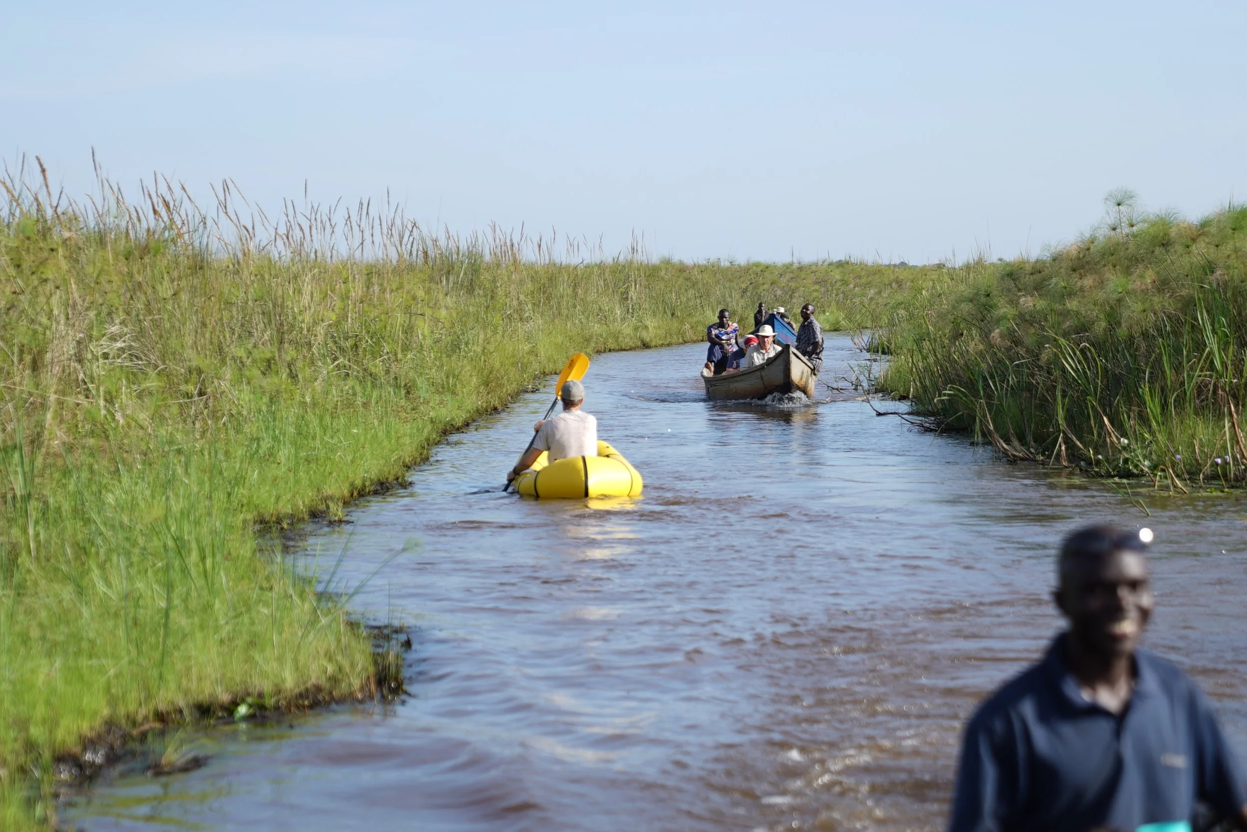
It’s busy in the small port of Nakiwogo. The ferry is about to leave and people are rushing to get on board. I manage to find myself a small landing for my packraft, away from the curious crowds. The water looks foul, with a green slushy film floating on the top surface. I push my raft into Lake Victoria to start my 50km journey across Mabamba Bay.
Since the start of the Covid-19 pandemic people have been searching for ways to escape the crowds of the city, and not just in Europe or the U.S. Outdoor sports like mountain biking and running have been booming worldwide ever since. For Ugandan cities like Kampala and Entebbe, this is no different, and both cities are blessed with an incredible outdoor playground on their doorstep, just a short boat ride away.
Boat landing sites give me a great sense of adventure. They breathe possible. You paddle for a couple of kilometres and you’re away from everything, you literally leave noise and air pollution behind, perhaps still looming over the city in the distance. Landing sites enable you to plan routes that would otherwise be impassable, creating lines on the map that wouldn’t exist without them. Throw yourself a packraft and mountain bike in the mix and you’ve got yourself a proper adventure.
The first port of call is Lulongo, a small landing site that’s primarily used by fishermen. It’s tucked away in a small bay, only 3km from Entebbe as the crow flies. But it’s a world away from buzzing boda bodas, shopping malls and tarmac. Arriving anywhere in rural Uganda as a mzungu (white person) usually attracts quite a bit of attention. Doing so in a bright yellow packraft with a bike strapped on top of it raises this to a whole new level. In all fairness, it might attract quite a few onlookers as well in say, Burton-Upon-Stather.
This is my very first time bikerafting. As with many of my adventures, I just go out and do it and figure it out along the way. In the words of Pipi Longstocking:
‘I have never tried that before, so I think I should definitely be able to do that’.
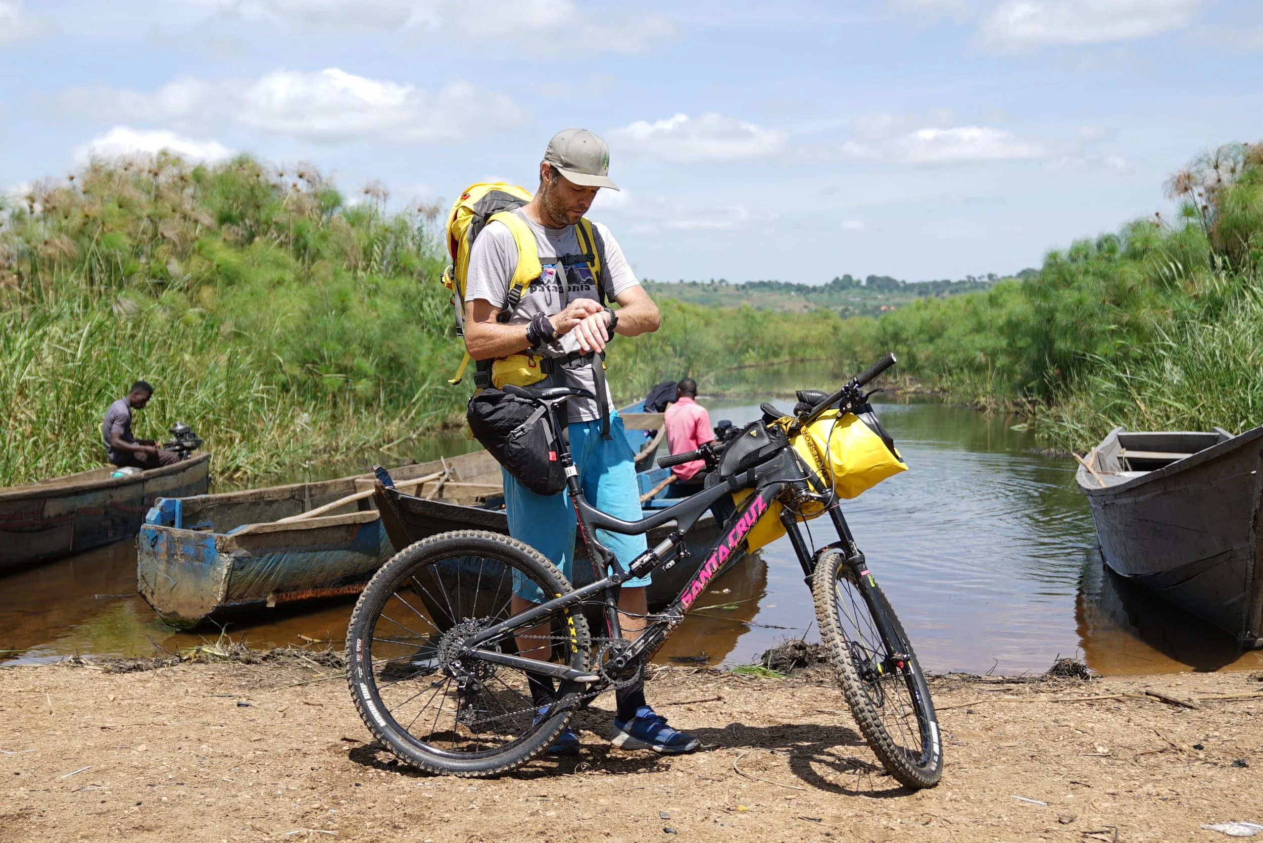
I’m packing up the raft, and strap it onto my handle bars to start the second stage of my journey. It’s easy cruising on the numerous small community trails that connect quaint villages and farmland. With a sense of direction, you can avoid riding on main dirt roads and stick to beautiful single tracks that wind their way through the fertile fields of Central Uganda.
Today’s goal is a lush hill called Nkima, a spectacular spot that looks out over the vast swamp of Mabamba Bay and Lake Victoria. Nature reserves in Uganda come in different shapes and sizes, there’s the explicit beauty of places like the Virunga volcanoes in the south of the country and the endless savannah of Murchison Falls National Park in the north.
In some places, you need to get closer and immerse yourself in that environment to really appreciate their natural splendour. The wetlands in Uganda are one of those places – and the great thing is, you don’t have to travel far to get there.

After a delicious lunch at the Nkima Forest Lodge, perched on top of the hill amidst a dense, old-growth forest, I head down with just my raft to search for one of the most elusive birds in East Africa, the Shoebill Stork. It’s the strangest prehistoric-looking bird, more suited to a Jurassic Park film set rather than the real world. It’s notoriously hard to find, but if you do find it, it usually stays put, feeling totally unthreatened by humans.
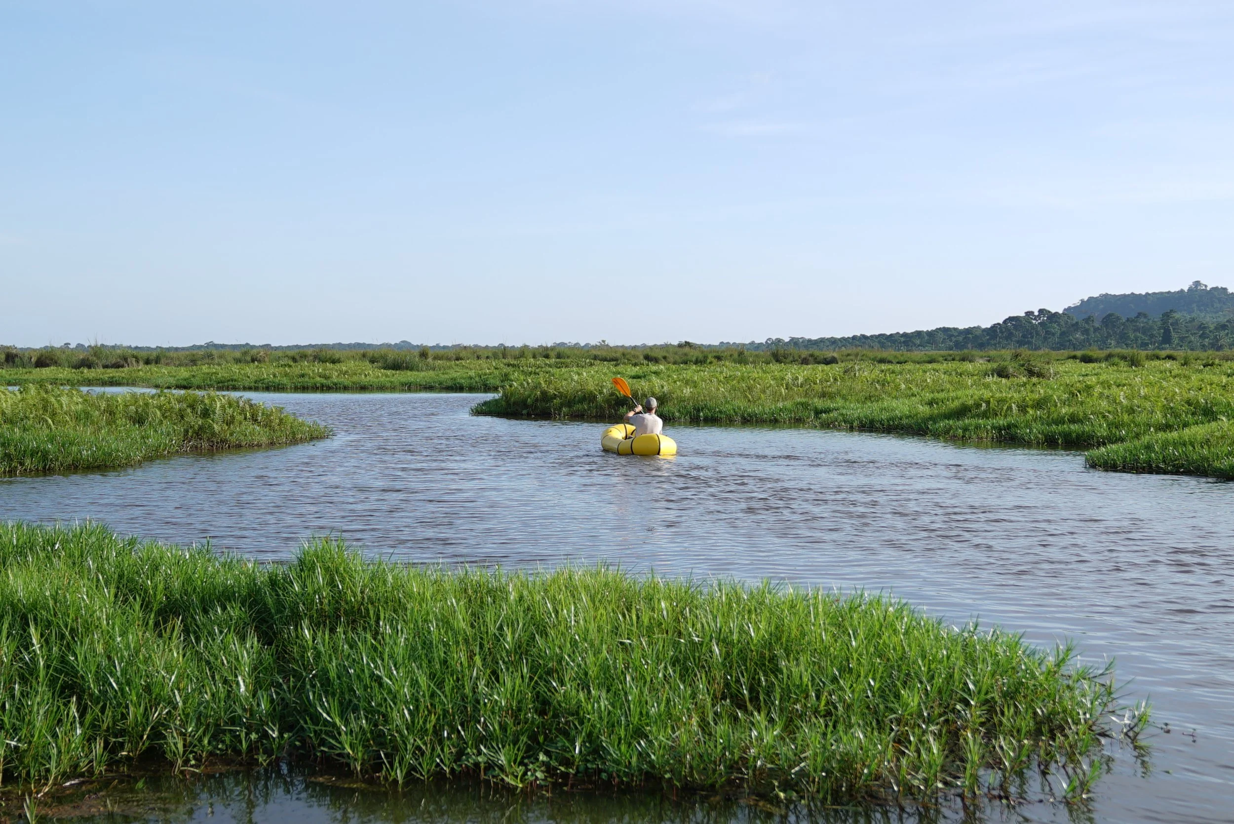
The Mabamba wetland is a vast papyrus swamp with a labyrinth of narrow waterways. It is designated as a Ramsar site to protect this vulnerable habitat for waterbirds, mammals and aquatic life. I’m gliding through one of the channels where the shoebill is often seen, it’s silent and I realise just how understated this place is. The only thing I hear is my paddle stroke and some of the swamp’s residents, like the African Jacana and Goliath Heron.
After pushing my boat forward with my arms through a particular narrow channel, suddenly I’m close up with the Shoebill. It looks me straight in the eyes, undeterred. If this water safari was on land, I guess I could say I ticked off one of the big five.
The next morning, I am keen to leave before sunrise to beat the midday heat, as this expedition is right on the equator. I’m setting up my raft with a crowd, as usual. I hear them chatting and pointing with a slight worry on their faces, and immediately I think there might be something I don’t know but should. Crocodiles? Hippos? When I ask one of the men what the discussion is about, he laughs at my worries.
‘They think your boat will not make it to the other side. The reeds and papyrus will pierce through it,’ he explains.
They probably think this raft is an ordinary dinghy that springs a leak at the first brush with vegetation. I assure them I should be fine, and besides that, I can swim!
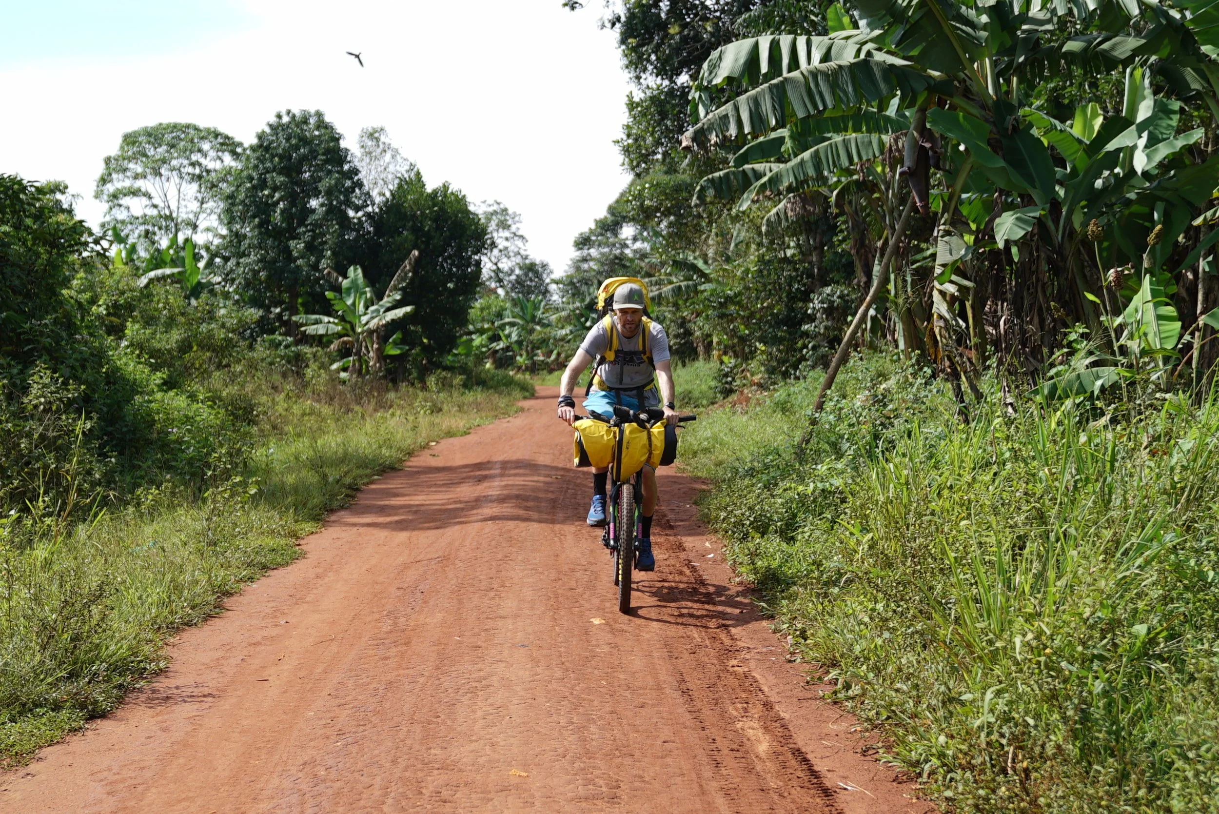
Without any troubles I make it to the other side, Busi Island. This is an isolated spot, not connected to the mainland and almost traffic-free. I peek at the map and see an interesting track skimming the northern part of the island. It’s a true cyclist’s paradise with a maze of small tracks and trails. Tourists don’t go here, and wherever I go I’m chased by excited kids, trying to outrun me. Via a broad ridge that forms the backbone of the island, I’m navigating to the channel that connects with the mainland.
Far away from the bustling tourist hot spots with their oversized Toyota LandCruisers and swanky lodges; drifting through the lush vegetation, navigating the skinny red dirt trails and rolling through sleepy villages with thatched rooftops, I look back – this is the adventure I’m looking for.
Rivers, Ridges & Rainforest
The Ultimate Ugandan Traverse
Crossing Southwest Uganda on foot, by bike and raft
Text and photos by Jan Bakker
Uganda is known for its incredible diversity of landscapes. Despite the relatively small size of the country (approximately 241,553 square km, of comparable size to the UK) it boasts wide-open savannah plains, dense jungles, high altitude mountains and numerous lakes and rivers. And perhaps nowhere else on the African continent can you find these geographical wonders so close to one another as in the southwest of Uganda. With a small team of intrepid adventurers, I set out to attempt a human-powered journey on foot, by bike, and by raft, slicing right across this lush and vibrant part of the world.

A topographical map of Uganda has always sparked my imagination. It’s a kaleidoscope of landscapes with peaks, lakes and forests connected through rural roads and trails. Zoom in on a map of the southwest, and things get even more interesting: the multiple blue dots are high altitude lakes in the shadow of the towering Virunga volcanoes. Spread across three national parks, they form a formidable barrier on the borders of Uganda, Rwanda and the Democratic Republic of Congo and are home to one of Africa’s most intriguing animals: the mountain gorilla. The fertile land around the volcanoes has attracted humans to every nook and cranny, creating a vast network of pathways connecting the villages and fields. Further north, the altitude drops and the landscape transforms into savannah plains, teeming with wildlife.

“Should I climb up the ladder or to the side of it?” Asks Charlie, one of the team members on our epic trip across what is sometimes dubbed as the “Gorilla Highlands”. Mount Gahinga has become very steep as we approach the summit and the most tricky sections are covered with a series of rickety ladders constructed from tree branches. They are slippery and require good balance. At nearly 3500 metres, the mountain’s summit is shrouded in fast-moving clouds, making the hike up an almost mystical experience. Occasionally the clouds lift and we catch a glimpse of its bigger neighbour, Muhavura. The climb to the top of Gahinga marks the start of our multi-discipline journey that takes us far off-the-beaten path.
Creating a mountain bike route from the foot of the volcanoes to one of Uganda’s most beautiful lakes, Mutanda, is like being a kid in a candy store. Endless small tracks weave across the hilly landscape. The idea is to avoid the main roads as much as possible and connect three of the region’s stunning lakes. Together with Ugandan cycling specialist Red Dirt Uganda we plotted the best possible route: it starts with a traverse along the edge of Mgahinga Gorilla National Park, with a flowy trail and thrilling downhill sections. After a quick Ugandan snack (the popular rolex, eggs rolled in a chapati) at the border post of Kyanika, we roll on to Lake Chahafi while navigating the bumpy lava bedrock tracks. Here, things get harder: we scale 15% gradients while we endeavour to keep ahead of an army of schoolchildren all calling out for our attention. After an afternoon of challenging ups and downs, a couple of breakdowns (and plenty of fun encounters with the community) we reach the southern shore of Lake Mutanda, one of the few lakes you can swim in without the fear of getting munched by crocs or hippos!

Lake Mutanda is silent, unlike most bigger lakes in Uganda. There are few motorised boats as there is no trading centre on the lake. Our packrafts glide through the glassy water, the Virunga mountain giants forming a stunning backdrop. We pass a number of islands and the occasional fisherman in a dug-out canoe. A quick lunch and snooze at the fabulous Mutanda Lake Resort charges our batteries for the short but punchy bike ride to the edge of Bwindi Impenetrable Forest. Tomorrow we will cross this pristine jungle on foot via the Ivy River Trail and hope for a chance encounter with the elusive mountain gorilla.

The descent into Bwindi is like entering a lost world, where we imagine dinosaurs could pop up at any moment. We hear a distant quarrel among a family of chimpanzees and the wildlife ranger tells us gorillas have been spotted close to our route. The trail is somewhat overgrown and muddy, adding to the sense of adventure. (In places, this incredible national park certainly lives up to its impenetrable name). We cross numerous bridges and gradually the trail becomes easier. After 14 kilometres of hiking we arrive on the other side of Bwindi, having done a full traverse on foot. Unfortunately we didn’t have a chance gorilla sighting but we leave the park with a deep appreciation for this unique protected rainforest.

Our bike ride to the Birira River was circled in red as the toughest day of our traverse. The initial 30 kilometres are fairly easy, with some amazing tracks across the endless neon green tea fields. After crossing the Ishasha river, we are reminded why this stage is the crux of our human-powered quest: the road goes straight into a climb with a gradient of over 10%. Add the thunderstorm that’s looming in the distance, and we are in for an interesting few hours of cycling.

Just as the heavens open, we find shelter in a small local eatery where we are treated to a hot meal of matoke (steamed banana) and beans and endless cups of tea. The final stretch is like a stage in the Tour de France but on rough, somewhat technical trails. We tackle ultra-steep climbs, one after another; even Sjaak, our strongest team member, shows signs of fatigue. Our reward is a swooping downhill ride to the river where the Sana Gorilla Rafting team is waiting for us with a roaring fire and cold beers.

The Birira river was only opened for white water rafting in 2023 and is very different from the White Nile around Jinja in eastern Uganda. The Birira flows through a narrow valley with exciting rapids bisecting steep hills covered with matoke trees. Here locals use age-old techniques to produce a potent gin from the matoke. There’s a look of disbelief when we whizz past in our raft! To add to the expedition feel we camp roughly halfway in the bush.
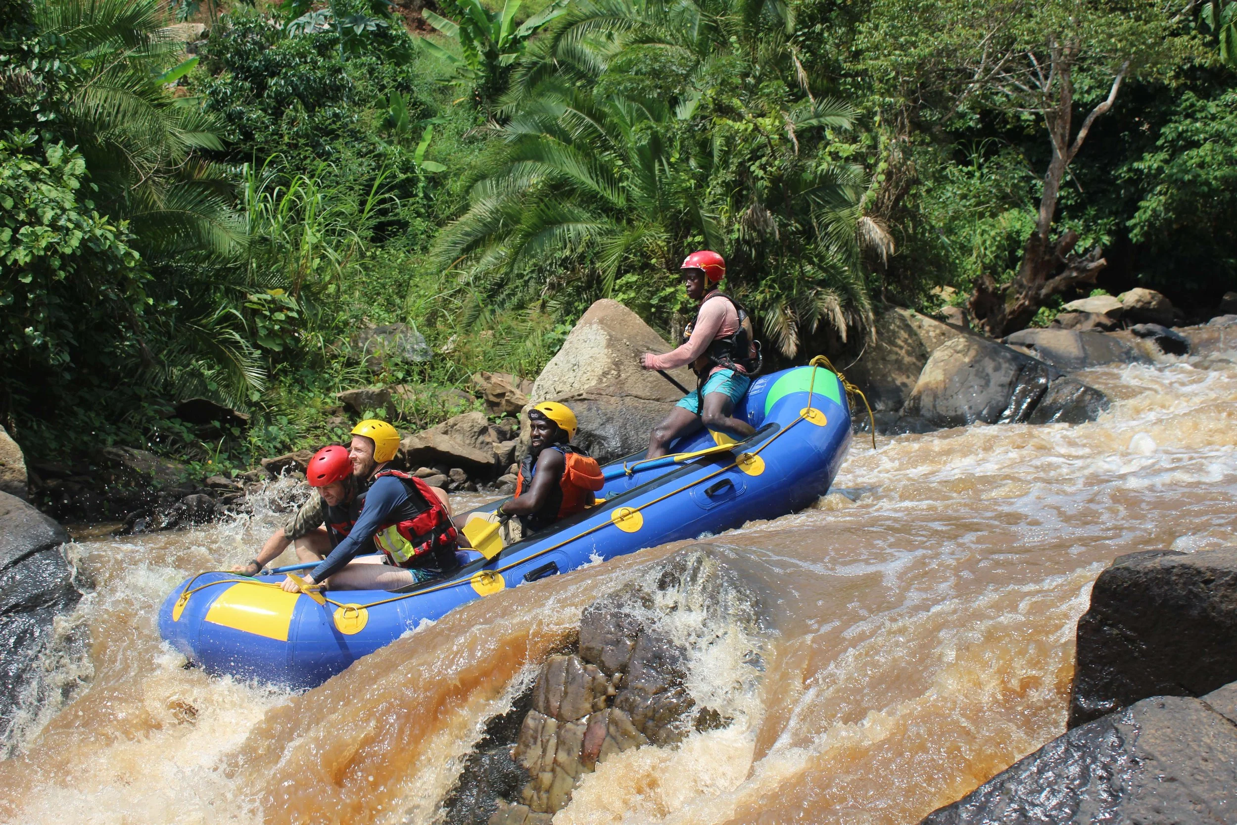
For the final stretch we hop back in the individual packrafts, but we are forced to bypass a section of the river due to a waterfall. To stay true to the human-powered nature of the trip we cycle to the next bridge from where we paddle our mini-rafts to the edge of Queen Elizabeth National Park. At the park boundary things get a little more exciting than anticipated as Wolf, who has paddled the river very casually so far, struggles to reach the exit point and flips. We manage to retrieve the raft and get the entire team back on dry land.

Keen to do a similar trip? In 2026 two 11-day expeditions are planned across the jungles, rivers and savannah in the Southwest of Uganda:
18-28 April 2026
21-31 October 2026
See here for a detailed itinerary of this trip. We can change the itinerary to create a bespoke expedition from 4 days to 3 weeks. Get in touch for more information.
